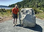
A state highway panel the project wanted replaced, a memorial stone it raised, a bronze plaque with fourteen names, and an interpretive sign that got as far as artwork.
The creator sets out the aim on his own project index: “The 2023 Umpqua
Memorial Project is focused on three historical markers and an event: 1)
Replacement of the Bolon Island ‘Jedediah Smith’ historical marker with one
that is more relevant to signficiant local events that took place from 1826
to 1828; 2) Installation of an Umpqua Memorial Stone commemorating the 15 men
killed nearby on July 14, 1828; 3) Installation of an 1828 Historical Sign
interpreting events associated with the October 28, 1828 burial of their
remains; and 4) Dedication of the Memorial Stone on October 28, 2023.”
Three of the four happened. This page follows each in turn. Where the
project’s papers give the ground itself — a coordinate, a survey
description, a road intersection, a map with the place marked — the Library
catalogues the paper and publishes none of it.
The Bolon Island marker
On Highway 101 at Bolon Island, outside Reedsport, a stone marker with an
inset bronze plaque has stood for about ninety years. Beside it the State
put up a modern interpretive panel about Jedediah Smith. The committee
wanted that panel taken down and replaced, and said so to the state body
that owns it.
The original stone marker at Bolon Island. The creator writes of it: “Note that it is inset, 90 years old, and along a major highway and never vandalized… The objective is to be respectful, with simplicity, large lettering, and elegance as guides.”From the creator’s own Bolon Island photographs; his files do not name the photographer. Photographic Report of 15 June 2023, p. 6.
The modern state panel that the committee asked to have replaced — the text at close range.From the creator’s own Bolon Island photographs; his files do not name the photographer.
To the Culture Committee of the Confederated Tribes of Coos, Lower Umpqua and Siuslaw Indians
Written the evening of a presentation to the Tribes’ Culture Committee. It summarises the project in four parts — the Bolon Island sign, the memorial stone, the October dedication and the interpretive sign — and invites the Tribes to co-sponsor the stone. The Library prints no part of the routing header; the addresses of the tribal staff and committee members copied on it are not published.
Instead of a semi-accurate biography of Jedediah Smith and his travel routes through the western US, we propose that the sign focus more on local history and native people in 1826-1828 with the top portion having an 1826 quote from McLeod on first contact with HBC and the bottom portion having an 1828 quote from Rogers and mentioning the SJ&S encounter and burials.
Page 1
The more Tribal involvement in these observations, the better. There is true international significance to this history.
Page 1
To the Oregon Travel Information Council: “Bolon Island Sign Critique”
The Umpqua Memorial Committee’s formal request to the state body that owns the highway marker: take the present panel down and put up one that is accurate and local. It is the fullest statement of what the project thinks the sign gets wrong. Again the routing header is not reproduced.
Our request to the Historical Marker Committee is to: 1) remove the existing panel for reasons given below, 2) replace it with a panel that is more accurate and meaningful historically and more relevant locally, and 3) give these actions a high priority.
Page 1
Yet the new sign states “Skirmished with Kelawatsets” on the map, and in the text states: “A skirmish erupted between the trappers and local Native Americans, the Quuiich (L.Umpqua).” They weren’t “Americans,” native or otherwise, few people know that the “L.” stands for “Lower,” and it certainly wasn’t a “skirmish” that somehow “erupted.” This is politics and semantics, not history.
Page 1
The slight attention given the Native American/L. Umpqua/Kelawatsets/Quuiich and their “village” gives a distorted and inaccurate perspective of the people who lived here in 1826 and 1828. The conflict with Smith and his men had a significant and lasting impact on coastal families as well as on US and British claims of “Joint Occupancy.” These people are represented, but barely, and very poorly. These were the people who lived here for generations; Smith and his men, horses, and mules were just rude, wealthy visitors who would be gone shortly if they weren’t stopped first.
Page 2
The Library takes no view on whether the panel should be replaced, or on
what a sign should say. It publishes the committee’s argument because the
committee published it, and because a reader of this series ought to be
able to see the reasoning behind the project rather than only its results.
The creator’s Bolon Island folder, as he posts it. Twelve photographs of the two markers sit alongside it.
Photographs: the creator’s Bolon Island folder,
twelve files — the original monument, the replacement panel with a person
for scale, the text at close range, and eight general views made in June
and July 2023.
The memorial stone and its plaque
A stone was chosen at the Main Rock quarry near North Bend on 14 June 2023,
hauled and set at the mouth of the Smith River on 21 June, cut for a bronze
plaque in October, and dedicated at sunset on 28 October 2023 — the 195th
anniversary of the burial. The three photographic reports follow it step by
step:
choosing the stone,
moving it, and
the plaque and the dedication.
Every hour of labour, every machine and the stone itself were donated.
The creator’s own thumbnail for the stone-placement report.Bob Zybach, Photographic Report #2, 22 June 2023.
Smith, Jackson & Sublette “Free Trappers”
Thomas Daws
John Gaiter
John Hanna
Abraham Laplante
Joseph Lapointe
Emmanuel Lazarus
Toussaint Maréchal
Martin McCoy
Joseph Palmer
Peter Ranne
John Robaseu
Harrison Rogers
Charles Swift
Thomas Virgin
Died July 14, 1828
Dedicated October 28, 2023
Jedediah Smith Society
The plaque text as the creator prints it in his field report.
Photographic Report of 15 June 2023, page 7.
Fourteen names, as they are set out on the plaque cast for the memorial stone under the heading “Smith, Jackson & Sublette / ‘Free Trappers’ / Died July 14, 1828.” The project’s own accounts differ on whether fourteen or fifteen men were killed; the creator’s index says fifteen, his second field report says “the 14 or 15 beaver trappers killed near here,” and his article notes that the larger number “may include the Kalapuyan slave boy, Marion, who probably survived.” Who each of these men was, in the creator’s own notes, is on the
people page.
The ground itself was listed with the Oregon Commission on Historic
Cemeteries on 29 March 2023. The Commission’s letter of confirmation says
only that “the Smith Jackson & Sublette Burial Site in Douglas County is
listed with the Oregon Commission on Historic Cemeteries,” and that the
listing brings it under the state’s historic-cemetery law. The application
behind that listing is a different matter: it is the one document in this
series that sets out the site’s legal description and coordinates, and it
also carries private addresses and telephone numbers. It is catalogued
below and nothing out of it is published.
Douglas County Public Works, 2 June 2023. Third-party record; identified by reference.
The interpretive sign, and what it was to say
The fourth object was an interpretive sign on Douglas County right-of-way —
county rather than state, which the creator noted gave “far more leeway to
content and design.” Between February and November 2023 he drafted the text
four times, a quotation and a budget came in from the sign fabricator, and
a graphic artist laid out two sheets of artwork. The creator’s own files do
not record the sign being installed.
What the sign was to carry is the most substantial piece of history in this
whole series: five passages of Rogers’s journal from the week before the
attack, McLoughlin’s report of what Arthur Black told him, the account an
Umpqua chief gave McLeod that October, and McLeod’s own entry for the day
of the burial. They are printed here from the draft of 20 October 2023.
From the Journal of Harrison G. Rogers
July 8, 1828. . . . the Inds. very numerous, they call themselves the Ka Koosh. They commenced trading shell and scale fish, rasberrys, strawberrys, and 2 other kinds of bury that I am unacquainted with, also some fur skins. In the evening, we found they had been shooting arrows into 8 of our horses and mules; 3 mules and one horse died shortly after they were shot. The Inds. all left camp, but the 2 that acts as interpreters; they tell us that one Ind. got mad on account of a trade he made and killed the mules and horses. The weather still good. One horse left today that was maimed.
Draft of 20 October 2023, page 1
From the Journal of Harrison G. Rogers
July 9, 1828. . . . We crossed in Ind. canoes; a great many Inds. live along the river bank; there houses built after the fashion of a shed. A great many Inds. in camp with fish and berris for sale; the men bought them as fast as they brought them. We talked with the chiefs about those Inds. shooting our horses, but could get but little satisfaction as they say that they were not accessary to it, and we, finding them so numerous and the travelling being so bad, we thought it advisable to let it pass at present without notice. We bought a number of beaver, land, and sea otter skins from them in the course of the day.
Draft of 20 October 2023, page 1
From the Journal of Harrison G. Rogers
July 11, 1828. To-day we enc. where there was some Inds. living; a number of them speak Chinook; 70 or 80 in camp; they bring us fish and berris and appear friendly; we buy those articles from them at a pretty dear rate. Those Inds call themselves the Omp quch.
Draft of 20 October 2023, page 1
From the Journal of Harrison G. Rogers
July 12, 1828. . . . Had several Inds. along; one of the Ind. stole an ax and we were obliged to seize him for the purpose of tying him before we could scare him to make him give it up. Capt. Smith and one of them caught him and put a cord round his neck, and the rest of us stood with our guns ready in case they made any resistance, there was about 50 Inds. present but did not pretend to resist tying the other . . .
Draft of 20 October 2023, page 1
From the Journal of Harrison G. Rogers
July 13, 1828. We made a pretty good start this morning, directing our course along the bay, east and travelled 4 miles and enc. 50 or 60 Inds in camp again to-day (we traded 15 or 20 beaver skins from them, some elk meat and tallow, also some lamprey eels). The traveling quite mirery in places; we got a number of our pack horses mired, and had to bridge several places. A considerable thunder shower this morning, and rain at intervals through the day. Those Inds. tell us after we get up the river 15 or 20 miles we will have good travelling to the Wel Hammett or Multinomah, where the Callipoo Inds. live.
Draft of 20 October 2023, page 2
Report by John McLoughlin to the Hudson’s Bay Company Governor & Committee
August 11, 1828. Honble. Sirs, On the 8th Inst. at 10 P.M. an American of the name of Black reached this place, in his opinion at the time, the only survivor of a Party of Nineteen (19) Americans, the remainder having been massacred by the Natives of the Umqua River. Black says that he and seventeen others were engaged to Mr. Smith . . . they left St. Francisco January last with about three hundred Horses bound for their Depot at Salt Lake. . . . At the moment of attack Mr. Smith was off with two men in a Canoe to ascend & examine Bridge River, a stream that flows into the Umpqua, to see if he could find a road to take his Horses -- a short time after Mr. Smiths departure, their being about a hundred Indians in the Camp & the Americans busy arranging their arms which got wet the day previous, the Indians suddenly rushed on them . . . -- on the 10 Inst. (yesterday) at mid-day Mr. Smith arrived with the two men who were with him in the Canoe . . who escaped by paddling to the opposite bank . . . The Indians who accompanied Mr. Smith to this place also report that the quarrel originated about an axe & the Natives conceiving them to be a different people from us had acted in this treacherous manner towards them.
Draft of 20 October 2023, page 3
Alexander McLeod Journal Entry
October 28, 1828. Fine Weather -- Proceeded to the Sea -- Stoped at the entrance of the North Branch, where Mr. Smiths Party were destroyed, and a Sad Spectacle of Indian barbarity presented itself to our View, the Skeletons of eleven of those Miserabl Sufferers lying bleaching in the Sun, after paying the last Service to their remains we continued forward and made the Coast, no Indians in the Vicinity, contrary to their former Custom as several Villages used to be about this place, the Natives are now more Collected than formerly --
Draft of 20 October 2023, page 6
The passage the creator heads “Native Account of Event by Umpqua Chief
Starnoose,” from the same draft, is printed in full on the
1828 record page.
Transcribed from
his draft; the ligatures in his PDF do not
survive text extraction and have been restored. Nothing else is altered.
The draft dates McLoughlin’s report 11 August 1828; an earlier draft and
the file in his References folder date the same document 10 August.
The creator’s Sign / Design folder. Three files are withheld: they reproduce the 1857–58 General Land Office survey that marks the place.
Quotation and proof from the sign fabricator, Sea Reach. Third-party commercial document; identified by reference.
Sponsors and acknowledgements
The creator keeps a sponsors page and updates it as the memorial develops.
Its own preamble reads: “The following individuals, organizations, and
businesses have contributed time, services, materials, and funding needed to
create and develop the Umpqua Memorial Project.” The table below is his,
reproduced as he publishes it: organisation, the person he names as the
contact, and the town the business is in. The Library adds nothing to it and
publishes no address, telephone number or email for anyone.
Organisation
Contact
Location
Bronzecraft Memorials
Larry Hager
Wamic, OR
Coos Bay Timber Operators
David Gould
North Bend, OR
Douglas County Public Works
Steve Williams
Roseburg, OR
Ellyn Amalia Designs
Ellyn Mole
Creswell, OR
FedEx Print & Shipping
Matthew Le Shay
Eugene, OR
Jedediah Smith Society
Milton von Damm
Berkeley, CA
K2 Consulting
Wayne & Tope Knauf
Lodi, CA
Main Rock Products
Mike Main
North Bend, OR
Mast Brothers
Josh Mast
Reedsport, OR
Northwest Canine Resources
Cathy Schneider
Oakland, OR
NW Maps Co.
Bob Zybach
Cottage Grove, OR
Oregon-California Trails Association
Dave Welch
Independence, MO
The Oregonian
Lori Tobias
Portland, OR
Pacific Memorials
Dale Hanson
Wilbur, OR
Phoenix Reforestation
David Katz
Eddyville, OR
R3 Engraving & Signs
Kiersten Shettlesworth
Corvallis, OR
Richardson Masonry
Stu Richardson
Reedsport, OR
Roseburg Forest Products
Allyn Ford
Roseburg, OR
Southport Lumber Co.
Jason Smith
North Bend, OR
The World
David Rupkalvis
Coos Bay, OR
The creator’s sponsors page.
He also records that “initial funding was also provided by the national
Jedediah Smith Society and the Oregon-California Trails Association.”
Documents in other hands
Seven documents in the marker folders were made by someone other than the
creator, or contain material the Library does not publish. Each is
catalogued: who made it, when, what it is, and where his copy is.
Third-party and withheld documents from the marker folders.
Letter from Kuri Gill, Historic Cemeteries Program Coordinator, Oregon Parks and Recreation Department, confirming that “the Smith Jackson & Sublette Burial Site in Douglas County is listed with the Oregon Commission on Historic Cemeteries.” A record of the State of Oregon. 1 page.
The application to the Oregon Commission on Historic Cemeteries, completed by the creator. It is the only document in this series that gives the site’s legal description and coordinates, and it also carries private addresses and telephone numbers. Catalogued here; nothing out of it is published. 3 pages.
Douglas County Public Works, 2 June 2023 — the county side of placing the stone. Scanned without a text layer. Third-party work; identified by reference. 3 pages.
Interpretive-sign artwork by Ellyn Mole, Ellyn Amalia Designs, 24 October 2023. Third-party work by a named artist; identified by reference. It reproduces the 1858 survey map. 1 page.